Heritage Reports including Macclesfield
Two major heritage reports in 1983 and 2004 gave fulsome descriptions of most buildings in Macclesfield at the time.
2004 Mt Barker Heritage Report
1983 Meadows Heritage Report
The full report can be downloaded here.
Macclesfield
The foundation of Macclesfield and its surrounds is inextricably tied to the Special Surveys which opened up this area at an early date. B. Hack's Three Brothers Survey established the area around Echunga (Region 4), Dutton's Mount Barker Survey established the Mount Barker and Hahndorf regions, Hall and Mein's Angas Survey led to the settlement of the Strathalbyn area, and Flaxman's Meadows Survey with Morphett's Green
Hills Survey established the area to be dealt with in the next section (Region 6). Settlement at Macclesfield and the area surrounding the township was provided for by the last of these Special Surveys, which was effectively taken by members of the Davenport family. Macclesfield was named in honour of the Earl of Macclesfield in England.
This region has been characterised by a high degree of developmental continuity due to the lengthy
presence of the pioneer settlers and original landholders. This continuity is most marked in the Macclesfield area, probably more so than in any of the other Surveys. The Davenports remained in control of much of the land selected from this Special Survey until at least the 1870s. In addition, much of the land surrounding Macclesfield was taken for country estates, since the Special Survey had attracted people of capital with aspirations for setting up large holdings as homes for the gentry involved in managing groups of farm labourers and tenants.
The influence of these large estates has been such that modern maps still include the
locations of the country estates of Robert Davenport, 'Battunga'; B. Austin, 'Lashbrooke'; the original house of Edward Austin, 'Glenella' and the Rankine property, 'Blackwood Park'. Their owners tended to be prominent in the affairs of South Australia generally, as well as in the development of the Macclesfield district. These estates, therefore, have significance far beyond any intrinsic merit and are fortunate to retain a major part of their original nuclei.
The estates to develop at a later stage were the Paris Creek Estate, associated with John and Thomas
Bowman of 'Poltalloch' and 'Campbell Park' respectively and the property known as 'Trenance', which was founded and is still run by members of the Bonython family.
As well as estate names, landmarks survive which commemorate the activities of early settlers; Dyer's Gully, Marker's Bridge, Edmond's Hill, Dickie Tonkin's Bridge, White Elephant Bridge, the Pudding Bag and Pipeclay Hill.
Major landscape features would include Temple Bar, where two bold hills 'guard' a western entrance to Macclesfield presumably analogous in the mind of the original settler in the area, to the Temple Bar which guarded the City of London. The name Bugle Ranges was given to the area due supposedly to a bullock notorious for straying into that locality, east of Macclesfield. Green Hills, to the west of the town is an obvious reference to the verdant pasture of that area; while Flaxley is believed to have been named after a village in Gloucestershire. Sheepwash commemorates a point where creek waters were used to wash the sheep of early settlers and Watergate near Flaxley was suggested by the local topography, where a small gorge and creek cut through the hill country. Paris Creek was named after Robert Paris, who purchased land near the headwaters of the creek in 1859. Region 5 is bounded roughly on the south, north and east by the District Council Boundary and on the west by the Hack Range, Bull Knob and Paris Creek.
In December 1837, an expedition consisting of Robert Cock, William Finlayson, A. Wyatt and G. Barton made their way from Adelaide to Lake Alexandrina through the Mount Lofty Ranges, naming the Angas River on their return. Their report on the area traversed, of which the site of Macclesfield was a part, was flattering and indicated considerable potential for the depasturing of cattle. Evidently the overlanders of livestock took advantage of this, for it has been recorded that in 1839 Bonney brought his herd through from Port Phillip close to the site of the town of Macclesfield.
The Special Survey taken by G. F. Davenport 'about the upper course and branches of the River Angas', resulted from peculiar Land Order No 162 for 4416 acres, issued to George Davenport (Oxford Banker and a Director of the South Australian Company), Frederick Luck and Roger Cunliffe, who took a quarter and an eighth share of the survey respectively. Davenport's son, George Francis Davenport evidently acted as agent for his father and partners, for G. Davenport, F. Luck and R. Cunliffe claimed a Special Survey of 15,000 acres 155 at or near Mount Gawler at Port Lincoln. However, as David McLaren recorded at the time (1840), 'one of the most wonderful and unaccountable circumstances connected with Special Surveys has occurred ... Mr Davenport has declared a Special Survey although he admitted to Mr Giles on his return from Port Lincoln
that he had not seen above 1,000 acres of good land.'
G. F. Davenport later withdrew the claim for this area and applied for land near the site of the present
township of Macclesfield.
The minutes of a meeting held 12 June 1840 state that G. F. Davenport, Esq, as agent for George Davenport, F. Luck and R. Cunliffe, claimed a Special Survey of 15000 acres lying 'generally
to the east of Mount Dutton and the Three Brothers Survey and north and east of a survey claimed by Mr Morphett or including any part or parts of Morphett's survey not selected by him.' This land was claimed by virtue of Peculiar Land Order No 162, taken in London and dated 22 October 1839, which entitled the owner
to 4416 acres, 576 of which were to be claimed and marked out as a town.
The Survey was carried out by the Government Surveyors, Burslem and Nixon in 1840-41 and although a number of lots were drawn in 1844, the majority efland Grants were not issued until 10 August 1850. G. F. Davenport had supervised the initiation of the survey, but returned to England leaving Henry Giles, son of the manager of the South Australian Company to manage his affairs. It is likely that Giles arranged for the erection of a house for the Davenport family, for H. Giles, in The Register of 1 January 1842, requested tenders for a stone cottage at Macclesfield designed by the architect, Hancock. When G. F. Davenport returned to South Australia in 1843 with his wife Sarah, his brother Robert, his brother Samuel and Samuel's wife Margaret, a good stone cottage had been built at Macclesfield, an inn, the Goat's Head had been established and gardens in the town were cultivated by Messrs Maidment, Yates, Ellis and Lillecrapp.
G. F. Davenport died within five weeks of his return, probably of typhoid, and on 2 December 1846 their father died in England. A delay in the granting of lands was caused by the subsequent deaths of all principal parties in the original agreement. Arrangements for the respective estates were made by the surviving brothers in South Australia, Robert and Samuel, who became prominent in the affairs of the State.
George Davenport's land, along with the estate of his son George Francis Davenport, was divided amongst the four surviving brothers, John Marriott, Henry Devereux, Robert and Samuel. Robert and Samuel handled the affairs of John and Henry who remained in England. Nicol Alexander Mein and Charles Stirling, speculative investors in the neighbouring Strathalbyn area, obtained an interest in Luck's estate, while Frederick Harrison, who remained in England, purchased Cunliffe's land.
The form of the township of Macclesfield drawn up in 1841 by Burslem and Nixon was undoubtedly influenced by the picturesque locality, utilising a bend in the Angas River. The angled nature of the town is complemented by the 'open areas' within and surrounding the township. These spaces have been subsequently called parklands and indeed correspondence of 1844 held in the State Archives contains a map which specifies 'parklands, public pleasure grounds and a number of reserves'.
The central area around which the town is hinged is marked on this map, although not delineated as Davenport Square by which name it is now known. The assertion in the Mount Barker Courier of 6 November 1947 that this' ... Village Green was given to the town by Mr Robert Davenport under the same conditions as the village greens in the Old Country' is confounded by a letter written by Samuel Davenport, in which he endeavoured to purchase additional Macclesfield town land, including a section of park land and public pleasure ground adjoining and to the south-west of the town.
Samuel Davenport's request was unsuccessful, for Governor Grey replied that he had no power to comply with the request. As Land Grants had not been issued for the unnumbered blocks in the town, such as parklands, Grey was in no position to sell parts of them and thus Davenport was, presumably, in no position to 'give' areas such as Davenport Square away, as The Mount Barker Courier has so generously suggested. By the late 1840s, however, Davenport Square had been named and is shown on a plan held in the State Archives. This action was probably undertaken in deference to the Davenport family.
Davenport's request for additional land to surround his cottage (which stood until 1956) was undoubtedly brought about by its immediate proximity to other dwellings in the town, as indicated by the following. 'The reason for this application is simply feeling compelled to take as my private property the house situate on acre 5 (subsequently acre 60) and which is of a character quite disproportioned to the situation in which it stands. It was put up at the advice of my late brother as a place for us all to come into on our arrival in the Colony ... my brother Robert purchased Watergate and my brother Francis died; and thus I was left alone with the house-Placed in the township and from the nature of the neighbourhood it does not serve the purpose of the farmer so that I have no hope of letting it. Therefore it would be a dead property ... unless I occupy it.'
In 1843 the houses of Ellis, Yates and Maidment were adjacent to Davenport's. In Cotter's Almanack of 1843 these early settlers are mentioned, in addition to Jackson of the Goat's Head Inn. Curiously, G. F. Davenport's cattle brand was recorded in the Almanack, while his brothers' names did not appear until Allen's Almanack of 1844, which with twenty entries for the area, indicates an established settlement.
One of the entries concerns a Walter Watson Hughes, whose contribution to the Macclesfield area appears to have been ignored in the past. Hughes, born in 1803, farmed at Temple Bar to the west of Macclesfield and his name appears as an owner of land in the area until at least 1879. Enrolment 74/8 (GRO) dated 29 May 1841, records the granting of part of the Green Hills Special Survey to John Morphett including an option by Hughes for the purchase of nine sections of land in the Temple Bar and Green Hills region. By 1844 Hughes was well established, with eighty acres wheat, three acres barley, three acres oats, two acres potatoes, two acres garden, 3000 ewes, 600 wethers, 112 cattle, twelve horses and eighty pigs. His property would have ranked with the most important settler in the area at this time - Dr John Rankine of 'Blackwood Park', south of Macclesfield. Hughes became a prominent South Australian citizen and was later knighted. He was a founder of and became the first donor to the University of Adelaide.
The depression of the early 1840s in South Australia, which bankrupted a number of early settlers,
including John Barton Hack, was responsible for the sale of George Deane's property 'Watergate' to Robert Davenport, who subsequently extended the estate and named it 'Battunga'. Dutton, in South Australia and its Mines, published in 1846, recorded the comments of Robert Davenport regarding his property in the Macclesfield area. 'The farm I purchased soon after I arrived in the Colony ... I found exceedingly productive of European grains and fruits, of almost every description. I have orchards and plantations of the apple, peach, almond, etc and some hundreds of trees. The olive thrives and the best varieties of the grape ... My best trees I got from Mr McArthur's garden in New South Wales. I have encouraged a few mechanics and labourers to settle around me, whose employ I could at any time command and who by reason of their productive little homesteads placing them in so independent a position, I have never found to be any incumbrance (sic). I have named the place Battunga after the native appellation, which the natives interpret to mean "the place of large trees".
With Robert at his estate, Samuel adopted the role of 'squire' in the town and wrote in 1843 to his father that the cottages had been enlarged as the 'improved conditions of the inmates allowed' and that fifty-five souls in the town occupied thirty-one acres. Samuel, who monitored the town's development, encouraged the establishment of a chapel, a good inn and a school. In 1841 Jackson's Goat's Head Inn opened and the Rev.]. B. Austin of 'Lashbrooke' established the Congregational Church in Macclesfield in 1844. It is likely that a Mr Evans became the first teacher in 1846.
In the 1840s and 1850s there were significant numbers of German families in the neighbourhood and the town was able to withstand the attractions of other nearby settlements sufficiently to establish itself as a viable community. By 1847, however, Robert Davenport was a little pessimistic of the town's development. 'I do not know exactly why it is that when other townships are advancing, Macclesfield declines. Strathalbyn and Nairne have many substantial stone buildings erected but Macclesfield is deserted by almost everyone.'
It would seem that the Davenports' rental agreements were largely responsible for the brake on
Macclesfield's development, for not only were tenant farmers renting the land, they were also expected to make improvements. For example, Section 2834 was leased to John Kellock, who was expected to erect a cottage and a stockyard within six months. In addition Samuel Davenport desired that a watermill be erected on the section and agreed to subsidise its construction on an equal basis up to £50. Only when these conditions were fulfilled was the rent then negotiated.
Although the South Australian Register of 10 June 1851 reported that Macclesfield was 'chiefly inhabited by German families', the same article mentioned an influx of Irish into the area. The German influence waned, probably due to the lack of a Lutheran Church, while the Irish population increased. This increase was largely due to the disastrous Irish famine of 1845-46 and the resultant emigration. The Irish population in the town grew to such a degree that Macclesfield was referred to by newspapers of the day as 'Paddy's Town' or 'the Hibernian Capital of the South'. The initiation of the influx was due to the District Councils of Macclesfield, Echunga, Nairne, Onkaparinga and Mount Barker agreeing to find employment for the female Irish immigrants who had been settled at Mount Barker, where a Catholic priest was in residence (the first outside the Adelaide area). As a result of the growing numbers, a Roman Catholic school and church were established in 1858.
In 1853 members of the region petitioned for a District Council. The list of petitioners indicates a strong German influence and, in fact, there remains much tangible evidence of their occupation of the area. Three eminent German botanists who emigrated from Schleswig-Holstein to the Macclesfield area were F. E. H. W. Krichauff, who occupied many important public offices in South Australia, Ferdinand von Muller, who established a world-wide reputation for his botanical research and D. L. T. Fischer who planted many orchards in the Macclesfield and Strathalbyn areas. Von Muller's cottage still stands at Bugle Ranges east of Macclesfield, two ruins survive from Krichauffs occupation of land, and fruit trees mark the site of Fischer's house, little commemoration for such significant contributions. Other Germans settling nearby were the Frahn, Klaebsch and Dancker families.
The Irish eked out an existence tied to their small parcels of land originally taken up under rental agreements. Descendants of pioneer settlers still farming the Macclesfield area would include Fry, Davis, Yates, Calaby, Anderson, Passfield, Edmonds, Le Mar (now Lemar), Nestor, McGrath, McCall, Waters and Klaebsch.
The stimulus for the development of Macclesfield in the 1850s came from the traffic passing through the area en route to the Victorian goldfields, as well as the local rushes at Echunga, which provided ready markets for Macclesfield's produce.
The single place of worship before 1851 was the Congregational Church built in 1848. This was followed in 1857 by the Wesleyan Church and the Anglican Church was in use in the same year. In 1858 the timber chapel in which the Roman Catholics worshipped was erected. A brewery was established in about 1854, the Macclesfield Hotel was opened in about 1855 and a school was built in 1857. In addition, during the 1850s a Mechanics Institute began, the Macclesfield and Strathalbyn Land and Building Society was operating and marble was quarried locally. In 1853 Macclesfield became a centre for Local Government.
As early as 1843 a weekly conveyance to Adelaide was begun by J. Lawrence. Early roads, in common with other areas, were disastrously maintained, until in 1854 District Councils were granted £20000 for the upkeep of transport networks. It was not until 1860, however, that Council supervised roads were built towards Meadows and Strathalbyn, and that a bridge and footbridge were built in the town across the River Angas.
2004 Mt Barker Heritage Report
The full report can be downloaded here.
A section of the report is copied here:
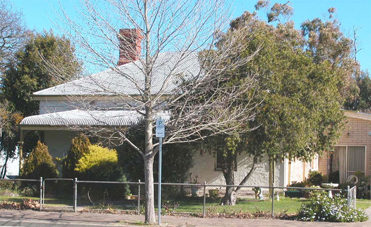
House, former schoolmaster's house Place no.: 818
Recommendation L ~ Recommended for inclusion in the local heritage register
Significant fabric [Painted] walls constructed of picked local stone with red-brick dressings including projecting coursing, hipped cgi roof with skillion section to rear, timber-framed openings with timber doors & timber-framed double-hung sash windows, red-brick chimneys with coursing to top, and hipped bull-
nose cgi verandah with timber posts.
Address 26 Venables St, Macclesfield
Land Description Lot 88, Hundred of Macclesfield
Certificate of Title CT 5536-313
State Heritage Status Nil HSA file no. Nil
Other Assessments Heritage Online 2004, Mount Barker Heritage Survey, included in the
proposed Macclesfield State Heritage Area MAA
Map Reference MAA 6.4
Photo filename Mt Barker Heritage Survey\MBHS Photos\Macclesfield\MC Venables26#.jpg
fr schoolmaster's house, 2004
DC Mount Barker Heritage Survey (2004) ~ Part 4 Local Heritage Recommendations
172 2 of 2 Anna Pope ~ Heritage Online
HISTORY
Date (approximate) 1898
Current Use House
Original Use Schoolmaster’s residence
For a few decades in the middle of the 19th century, Macclesfield was one of South Australia’s
most significant country towns. It was one of the Adelaide Hills’ earliest towns, being established in 1841, only two years after the first town (Nairne) was surveyed outside Adelaide.
Macclesfield’s most significant period of development was during the 1850s when the town provided services for passing miners and travellers as well as local farmers. During the 1840s and 50s, two hotels, several shops, a school, a brewery and four churches were established in the town. The town’s school was opened on the ‘VR’ designated allotment in 1855, and a schoolmaster's residence was constructed adjacent in c1898.
STATEMENT OF HERITAGE VALUE
This late-19th-century residence has important associations with the educational development of
Macclesfield, one of South Australia’s most significant early rural towns.
RELEVANT CRITERIA
(a) it displays historical, economic or social themes that are of importance to the local area,
having significant associations with the 19th-century educational development of Macclesfield.
REFERENCES
DC Mt Barker, Macclesfield file.
Faull, Jim [ed.] 1980, Macclesfield, reflections along the Angas.
Macclesfield Residents Association, Macclesfield Historic Walk [brochure].
Manning, Geoffrey H 1990, Manning's place names of South Australia, p 189.
Oral history: Betty White.
DC Mount Barker Heritage Survey (2004) ~ Part 4 Local Heritage Recommendations
Anna Pope ~ Heritage Online 1 of 2 173
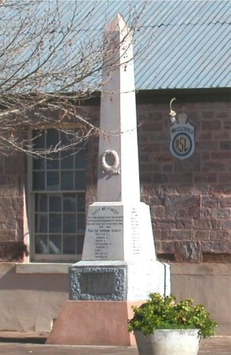
War Memorial Place no.: 820
Recommendation L ~ Recommended for inclusion in the local heritage register
Significant fabric Marble obelisk including plinth, projecting decorations and inscriptions.
Address 30 Venables St, Macclesfield
Land Description Lot 162, Hundred of Macclesfield
Certificate of Title CT 5868-907
State Heritage Status Nil HSA file no. Nil
Other Assessments Heritage Online 2004, Mount Barker Heritage Survey, included in the
proposed Macclesfield State Heritage Area MAA
Stark, P 1983, Meadows Heritage Survey, C200
Map Reference MAA 6.4
Photo filename Mt Barker Heritage Survey\MBHS Photos\Macclesfield\MC Venables 30
memorial.jpg
War Memorial, 2004DC Mount Barker Heritage Survey (2004) ~ Part 4 Local Heritage
Recommendations
174 2 of 2 Anna Pope ~ Heritage Online
War Memorial Place no.: 820
HISTORY
Date (approximate) 1920s
Current Use Memorial
Original Use Memorial
Like many Australian towns, the significant South Australian country town of Macclesfield suffered several casualties during World War I. The marble obelisk outside the former school was erected in the 1920s to commemorate local soldiers. It was originally located in Davenport Square.
STATEMENT OF HERITAGE VALUE
Macclesfield’s war memorial has significant associations with the early 20th century history of the
town and nation, and is a significant community place.
RELEVANT CRITERIA
(a) it displays historical, economic or social themes that are of importance to the local area, having significant associations with the early 20th century history of the town and nation.
(c) it has played an important part in the lives of local residents, especially those who have associations with the memorial or those commemorated by it.
REFERENCES
DC Mt Barker, Macclesfield file.
Faull, Jim [ed.] 1980, Macclesfield, reflections along the Angas.
Macclesfield Residents Association, Macclesfield Historic Walk [brochure].
Oral history: Betty White.
Stark, Paul 1983, Meadows Heritage, C200.
www.heritage.gov.au/ahpi, www.slsa.sa.gov.au, www.southaustralianhistory.com.au
DC Mount Barker Heritage Survey (2004) ~ Part 4 Local Heritage Recommendations
Anna Pope ~ Heritage Online 1 of 3 175
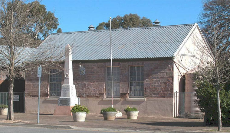
Hall, fr school, outbuilding & oak tree Place no.: 821
Recommendation L* ~ Recommended for inclusion in the local heritage register
Significant fabric School: walls constructed of coursed blocks of local pink-stone with stone voussoirs over cambered arch-topped openings, cgi gable roof, timber-framed openings with timber doors & timber-framed multi-paned double-hung sash windows.
WC: walls constructed of local stone with red-brick dressings and cgi skillion roof [excluding concrete block walling].
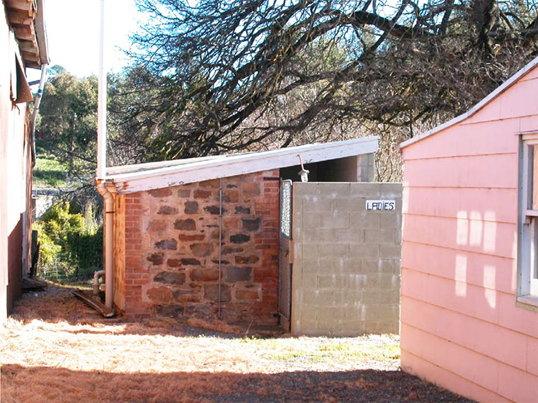
Outbuilding, toilet and mature oak tree to rear of school.
Address 30 Venables St, Macclesfield
Land Description Lot 162, Hundred of Macclesfield
Certificate of Title CT 5868-907
State Heritage Status Nil HSA file no. Nil
Other Assessments Heritage Online 2004, Mount Barker Heritage Survey, included in the
proposed Macclesfield State Heritage Area MAA
Veenstra, c1995, Item 8/07
Stark, P 1983, Meadows Heritage Survey, A 5.4.4
National Trust of South Australia, file 2038
Map Reference MAA 6.4
Photo filename Mt Barker Heritage Survey\MBHS Photos\Macclesfield\MC Venables 30
school. +wc.jpg
Former school, 2004DC Mount Barker Heritage Survey (2004) ~ Part 4 Local Heritage Recommendations
176 2 of 3 Anna Pope ~ Heritage Online
Hall, fr school, outbuilding & oak tree Place no.: 821
HISTORY
Date (approximate) 1855, 1881
Current Use RSL hall, WC and tree
Original Use School house and attached residence, WC and tree
For a few decades in the middle of the 19th century, Macclesfield was one of South Australia’s
most significant country towns. It was one of the Adelaide Hills’ earliest towns, being established in 1841, only two years after the first town (Nairne) was surveyed outside Adelaide.
Macclesfield’s most significant period of development was during the 1850s when the town provided services for passing miners and travellers as well as local farmers. During the 1840s and 50s, two hotels, several shops, a brewery and four churches were established in the town. In 1855, the town’s much-needed school was also constructed. First mentioned in the Register of 2 February, the plan was approved by the Central Board of Education on 15 August, and on 17 October, the Government granted a quarter of lot 88 to the school. This land had been designated ‘VR Reserve’ on the town’s original subdivision plan. The building was constructed in the next year and a half, and completed by 26 May 1857. It included a school-room and a residence for the headmaster which was first occupied by Mr Winter. The school was also used as the town’s Mechanics Institute, and was extended in 1881. A separate teacher’s residence was constructed next door in 1898, and the building was repaired in 1922. After the new school complex was established
adjacent to the old town cemetery in the mid 20th century, the original school building became an
RSL hall.
STATEMENT OF HERITAGE VALUE
This is an outstanding surviving example of a mid-19th-century school building which demonstrates high-quality school design & construction of the period, especially displaying fine local stonework.
The former school has significant associations with the early development of Macclesfield, and especially with its educational, cultural and social development.
RELEVANT CRITERIA
(a) it displays historical, economic or social themes that are of importance to the local area,
having significant associations with the early and ongoing educational, cultural and social
development of Macclesfield.
(b) it represents customs or ways of life that are characteristic of the local area, demonstrating
the typical way of life of early South Australian teachers, and the way in which their school
rooms were often attached to their residences.
(c) it has played an important part in the lives of local residents, especially those who have used
or been associated with the school, mechanics institute of RSL Hall.
(d) it displays aesthetic merit, design characteristics or construction techniques of significance to
the local area, being an outstanding surviving example of a mid-19th-century school building
which demonstrates high-quality school design & construction of the period, especially
displaying fine local stonework.
(g) in the case of a tree
it is of special historical significance or importance within the local area,DC Mount Barker Heritage Survey (2004) ~ Part 4 Local Heritage Recommendations
Anna Pope ~ Heritage Online 3 of 3 177
Hall, fr school, outbuilding & oak tree Place no.: 821
REFERENCES
DC Mt Barker, Macclesfield file.
Faull, Jim [ed.] 1980, Macclesfield, reflections along the Angas.
Faull, Jim & Gordon Young, 1986, People Places & Buildings, pp 99-104.
Local History Centre, heritage files & photographs.
McEwin, G G 1990, Macclesfield & Surrounds: A Title Search from alienation to current, pp 23-24.
Macclesfield Residents Association, Macclesfield Historic Walk [brochure].
Manning, Geoffrey H 1990, Manning's place names of South Australia, p 189.
National Trust of South Australia, file 2038.
Oral history: Betty White.
Stark, Paul 1983, Meadows Heritage, A 5.4.4 p 174.
The Register, 2 February 1855.
Veenstra, Paul c1995, Mount Barker District Heritage Survey [Report files], Item 8/07.
www.heritage.gov.au/ahpi, www.slsa.sa.gov.au, www.southaustralianhistory.com.au
rear of fr school showing outbuilding and edge of oak tree, 2004DC Mount Barker Heritage Survey (2004) ~ Part 4